
|
|
|
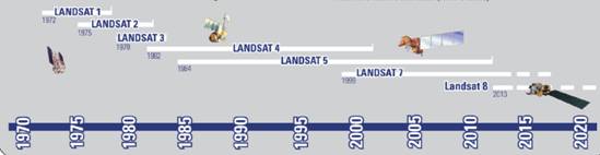
Landsat 系列衛星為美國太空總署 (NASA) 之地球觀測衛星,如圖1及表1所示,從 1972 年 Landsat-1 發射至今,運轉中有 Landsat-7 與 Landsat-8 。 Landsat-7 則於 1999 年 4 月發射升空,Landsat-8 則於 2013年 2 月發射升空,為太陽同步地球資源衛星,高度為 705 公里,運轉傾斜角為 98.2 ° 。通過赤道之時間約為當地時間上午10點,由北向南越過赤道,繞地球一圈週期約 98.9 分,每天繞行約 14 圈,每 16 天掃瞄同一地區。全球共有 233 個軌道,以 Landsat 所定義之全球參考系統 (World Reference System-2, WRS-2) 表示,定為 Path / Row 座標系,台灣地區處 Path 117-118 , Row 42-45 。Landsat-7 掃瞄覆蓋地面每一像幅 (Scene)約185公里×170公里,掃瞄一個像幅約費時 26.31 秒,在赤道附近相鄰兩張影像重疊量為百分之7.3,愈向兩極重疊愈多,在台灣地區重疊約百分之14。Landsat-7其影像拍攝方式是以垂直飛行方向使用鏡子旋轉做來回掃瞄之方式,稱為 Whisk-broom 感測器,而Landsat-8之感測器則為推掃式(Push-broom)感測器。Landsat-7 與 Landsat-8之掃瞄視野角 (FOV) 為 14.7 ° ,相當於地面 185 公里幅寬。
Landsat-7 ETM+ 有 8 個波段,其中波段 8 為全光譜波段,具有 15 公尺之空間解析度,波段 1~3( 可見光 ) 與波段 4,5,7( 近紅外光 ) 之空間解析度為 30 公尺,而波段 6 為熱紅外光,空間解析度則為 60 公尺。Landsat-8則有11個波段,其中波段 8 為全光譜波段,具有 15 公尺之空間解析度,波段 1~7與波段9之空間解析度為 30 公尺,而波段10及11 為熱紅外光,空間解析度則為 100 公尺。Landsat-7 ETM+之波譜範圍如表2所示,而Landsat-8之波譜範圍如表3所示
| Satellite | Launch | Decommissioned | Sensors |
|---|---|---|---|
| Landsat 1 | July 23, 1972 | January 6, 1978 | MSS/RBV |
| Landsat 2 | January 22, 1975 | July 27, 1983 | MSS/RBV |
| Landsat 3 | March 5, 1978 | September 7, 1983 | MSS/RBV |
| Landsat 4 | July 16, 1982 | June 15, 2001 | MSS/TM |
| Landsat 5 | March 1, 1984 | 2013 | MSS/TM |
| Landsat 6 | October 5, 1993 | Did not achieve orbit | ETM |
| Landsat 7 | April 15, 1999 | Operational | ETM+ |
| Landsat 8 | February 11, 2013 | Operational | OLI/TIRS |
| Spectral bands | Wavelength (micrometers) | Resolution (meters) |
|---|---|---|
| Band 1-blue-green | 0.45-0.52 | 30 |
| Band 2-green | 0.52-0.61 | 30 |
| Band 3-red | 0.63-0.69 | 30 |
| Band 4-reflected IR | 0.76-0.90 | 30 |
| Band 5-reflected IR | 1.55-1.75 | 30 |
| Band 6-thermal | 10.40-12.50 | 120 |
| Band 7-reflected IR | 2.08-2.35 | 30 |
| Band 8-panchromatics (Landsat 7) | 0.52-0.90 | 15 |
| Spectral bands | Wavelength (micrometers) | Resolution (meters) |
|---|---|---|
| Band 1-coastal/aerosol | 0.43-0.45 | 30 |
| Band 2-blue | 0.45-0.51 | 30 |
| Band 3-green | 0.53-0.59 | 30 |
| Band 4-red | 0.64-0.67 | 30 |
| Band 5-near IR | 0.85-0.88 | 30 |
| Band 6-SWIR-1 | 1.57-1.65 | 120 |
| Band 7-SWIR-1 | 2.11-2.29 | 30 |
| Band 8-panchromatics | 0.50-0.68 | 15 |
| Band 9-cirrus | 1.36-1.38 | 30 |
| Band 10-TIRS 1 | 10.60-11.19 | 100 |
| Band 11-TIRS 2 | 11.50-12.51 | 100 |
320317 桃園市中壢區五權里2鄰中大路300號 國立中央大學太空及遙測研究中心
學校電話:(03)422-7151 轉57600~57603; 中心專線電話:(03)4257232, 傳真:03-425-5535, E-mail: ncu7600@ncu.edu.tw
衛星影像申購 : (03)422-9332;(03)422-7151 轉57601 service@csrsr.ncu.edu.tw
隱私權政策聲明